

Philadelphia, PA—At the corner of Lancaster Avenue that intersects with Brown and Brooklyn streets stands a red brick building that was the site of Pennsylvania’s first Nation of Islam temple, where Malcolm X taught during visits to Philadelphia. Half a mile east, Rev. Dr. Martin Luther King, Jr. addressed an estimated 10,000 people at the intersection of Lancaster, Haverford, and 40th streets during his Freedom Now tour of 1965. The factory where Dr. Albert C. Barnes, collector behind The Barnes Foundation art museum, displayed fine works by artists around the world to his racially integrated work force in a factory that once stood about 0.2 miles from where King spoke. Some 3.5 miles separate the factory site from the African Episcopal Church of St. Thomas, founded in 1792 as the African Church, an outgrowth of The Free African Society.

But how many people are aware of the significance of these sites? The question stays on the mind of Abdul Muhammad, founder and curator of The New Africa Center Muslim American Museum and Archive at 4243 Lancaster Avenue, and founding director of the Islamic Cultural Preservation and Information Council, or ICPIC. As development driven by University of Pennsylvania, Drexel University and gentrification sprawl farther into West Philadelphia, Muhammad has taken steps to preserve the area’s history. Working in partnership with People’s Emergency Center (PEC) Community Development Corporation, and local historian Scott Maits, Muhammad is spreading knowledge of West Philadelphia history through a digital map.
Live at www.westphillyhistory.com since November 2016, The West Philadelphia History Map was designed by Interactive Mechanics, a local technology firm with a mission of social good, and funded in part by Local Initiatives Support Corporation (LISC), a nonprofit organization that invests in low-income neighborhoods. The map developed from ideas and concerns brought forth at a series of neighborhood planning meetings in 2011 and 2012. Residents on and surrounding Lancaster Avenue between 37th and 48th streets (Lower Lancaster) expressed an interest in doing more neighborhood identity projects, historic preservation, historic properties and arts and culture that celebrate the history of West Philadelphia. They suggested ways to document that history in analog and digital forms, such as historical markers, walking tours with audio apps and applying for historic district status.

According to Kevin Musselman, Manager of Neighborhood and Resource Planning at PEC, the decision to make an online history map came out of a conversation with Muhammad and Maits after learning of a funding opportunity from LISC “We decided we wanted to do a history project that allowed people to come together and share their stories along with documenting these stories geographically,” Musselman said.
Muhammad, who is a member of PEC’s neighborhood advisory council and arts and cultural committee, had been collecting information from the Preservation Alliance of Greater Philadelphia on sites important to the local black freedom movement for ICPIC’s plans to develop a walking tour of Lancaster Avenue. In 2015, he provided PEC with a list of 25 suggested sites for the map and photographs. Throughout 2016, ICPIC and PEC held community meetings about the project to determine which sites should be included. They’ve also invited anyone who has a story about West Philly or photographs of the area to share them.

Maits, PEC marketing coordinator Meg Lemieur, and Musselman are curating the map. Musselman said not all of the photos and stories that community members have provided have been about historically significant events, and the partnering organizations’ definition of “historic significance” is still in progress. Organizers have begun using smartphones to record oral histories at the meetings, and Musselman said the curators may add a category for personal stories to the map. “Any personal stories or photos will be attributed directly to the individual who provides that content,” and they will be presented as memories rather than facts, Musselman said. Additionally, Interactive Mechanics plans to create a mobile version of the map because most residents in the New Freedom District access the internet by smartphone.
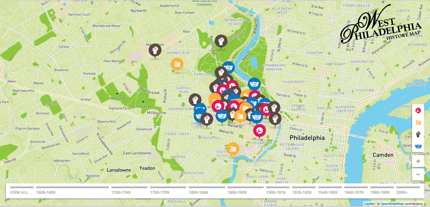
On a desktop or laptop screen, the West Philadelphia History Map appears much like a Google map, though the background color is a light green instead of a light gray. Viewers can zoom in and out of the map, and as of this posting, 57 specific addresses have been bookmarked or pinned. In this case, the pin is an icon representing arts and culture, social movements and civil rights, infrastructure, or physical development. Site visitors can click on individual icons to see a photograph and description of the location and a blurb about its significance. (Musselman writes the descriptions and blurbs, which he said are usually copied verbatim from a cited source.) Additionally, viewers can scan the map via a timeline at the bottom, starting from the year 1600. Currently the earliest designation on the map is for the Lenape, Iroquois and Susquehannock people, Native populations who lived along the Schuylkill River banks before English settlers arrived. Sites cover about seven square miles and can be found as far west as City Avenue, as far north as Belmont Mansion, and almost as far south as Grays Ferry Avenue. From the home page, visitors can browse the map by category.

Visitors to the West Philadelphia History Map also have the option to take a New Freedom Tour, a virtual tour that includes fourteen African American history sites already on the map, most of them in the Social Movements & Civil Rights category. The New Freedom Tour takes its name from ICPIC’s neighborhood redevelopment and preservation initiatives, which began with an effort to rebrand the area from Philadelphia’s “Promise Zone” to its “New Freedom District.” In January 2014, President Barack Obama designated five regions throughout the United States as Promise Zones to increase opportunity, improve quality education access, decrease crime, and create jobs in locations of deep and persistent poverty. The target area of Philadelphia’s Promise Zone is roughly two square miles in West Philadelphia—bounded by the Schuylkill River to the east, Girard Avenue to the north, 48th Street to the west, and Sansom Street to the south. It includes 35,315 residents with an overall poverty rate of 50.78%, nearly double the city’s rate of 26.9%.

The New Freedom District plans also include New Freedom Square, a green space and small concert stage that would sit on what is currently a vacant lot at 4234 Lancaster, and the renovation of New Africa Center as a multipurpose facility.
Through the New Freedom District rebranding and development efforts, Muhammad said he wanted “to give the community a new sense of ownership, a new sense of bonding as a community.” Knowing that people living in poverty often don’t feel like they’re significant, he hopes New Freedom District will inspire people with a new sense of citizenship and new sense of pride in their community. “People would realize their neighborhood had a history they could take pride in,” said Muhammad.
Muhammad sees the West Philly History Map as part of the New Freedom District initiatives and hopes it generates more interest in the neighborhood as a cultural history and tourism destination. “Our center is a cultural center. Our museum is a visitor’s destination. That can bring a whole new life in this neighborhood and new forms of employment,” Muhammad said.